Geographical location of Bihar:-
Introduction:-
Bihar is a land locked state lying in the eastern part of India although the outlet to the sea through the port of Kolkata is not far away. Bihar lies mid-way between the humid West Bengal in the east and the sub humid Uttar Pradesh in the west which provides it with a transitional position in respect of climate, economy and culture. It is bounded by Nepal in the north and by Jharkhand in the south. The Bihar plain is divided into two unequal halves by the river Ganga which flows through the middle from west to east.
Located in the Eastern part of India, Bihar is the 13th largest state of the country and constitutes only 2.86 % of the total land of India. On 15 November 2000, the southern part of Bihar was split to form the state of Jharkhand. Bihar is divided into 37 districts and has Patna as its capital. Bihar has a total area of 94,163 sq. km. and is located between 21°-58′-10″ N ~ 27°-31′-15″ N latitude and between 82°-19′-50″ E ~ 88°-17′-40″ E longitude. The elevation above sea level stands to 173 Feet.The location of Bihar is strategic. It is located in the eastern part of the country, which lies in the middle of the humid West Bengal and sub-humid Uttar Pradesh. The place enjoys close proximity to Nepal. There is Jharkhand in the South as well. The state of Bihar is fortunate to have river, Ganga running just in the middle of it from west to east. That is what makes the place even more significant. The river, Ganga is considered as one of the holy rivers of India since ages. This has made the state of Bihar preserve its rich historical culture in terms of religion much intensely as compared to other states. India’s largest mountains, the Himalayan Mountains are to the north of Bihar. If one goes to the south, one can find Chota Nagpur plateau. However, it has been a part of Jharkhand, which was in Bihar until the year 2000.
Geographical Structure of Bihar:-
The Geographical Structure of Bihar is embedded with younger geological structure in the North by Dharwarian rocks and older in the South by quaternary rocks. As far as the physiological structure is concern, Bihar is consists of Terai in the North-West, Gangetic Plain in the centre and Plateau in the Southern region.
Geology of Bihar:-
The Geology of Bihar corresponds the balance picture of the term geology because it is consists of younger (Tertiary Period) and older formation of rock (Pre-Cambrian period), and the plain was formed by filling up of a vast trough by the heavy loads of detritus carried by swiftly flowing rivers down the Southern slopes of newly uplifted Himalayas.
List of rocks found in geographical land area of Bihar:-
- Dharwar Rock:-
- Found in the South-Eastern part of Bihar like Munger, Jamui, and Nawada.
- They are made up of Quartzite, phyllite, Gneiss, Schist and slate.
- Region is dominated by mica-schists
- Vindhyan Rock:-

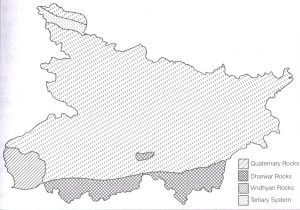
- Found in South- Western part of Bihar in between Kaimur district and
Sone river valley in Rohtas District.
- They are made up of sandstone, quartzite, limestone, dolomites and shale.
- Tertiary Rock:-
- Found in Himalayan terai region of Bihar.
- Formed by up warping of sediments deposited in Tethys Sea between Eurasian plate and Indian plate.
- Quaternary Rock:-
- Found in down warped section between Himalayas and Chhotanagpur Plateau
- They are made up of sandstones, alluvium, conglomerate, coarse gravel etc.
Physiographical Division of Bihar:-
Bihar is divided into three physiographic units on the basis of physical and structural conditions:-
- Shiwalik Range
- Bihar Plain
- Southern Plateau Region.
Shiwalik Range:-
This range shadows the state from Northern part of West Champaran district over an area 32 km long and 6-8 km wide and it is divided into sub-divided into three parts on the basis of variation:
- Ramanagar Doon
- Someshwar Range
- Harha Valley
Bihar Plain:-
The  plains of Bihar, adjoining Nepal, are drained by a number of rivers that have their catchments in the steep and geologically nascent Himalayas. Kosi, Gandak, Burhi Gandak, Bagmati, Kamla Balan, Mahananda and Adhwara Group of rivers originates in Nepal, carry high discharge and very high sediment load and drops it down in the plains of Bihar. About 65% of catchments area of these rivers falls in Nepal/Tibet and only 35% of catchments area lies in Bihar. Plains of north Bihar have recorded the highest number of floods during the last 30 years. In the years 1978, 1987, 1998, 2004 and 2007 Bihar witnessed high magnitudes of flood. The total area affected by floods has also increased during these years. Flood of 2004 demonstrates the severity of flood problem when a vast area of 234908 Sq Km was badly affected by the floods of Bagmati, Kamla & Adhwara groups of rivers causing loss of about 800 human lives, even when Ganga, the master drain was flowing low. It is located between Northern Mountains and Southern Plateau region which is bounded by 150m contour line in the North as well as in the South. This plain is sub-divided into two parts on the basis of characteristics:
- Northern Plain: It is located in East & West Champaran (Terai area with higher elevation), and Chaurs of Samastipur, Begusarai, Saharsa and Kathihar districts. Region is drained by Saryu, Gandak, Burhi Gandak, Bagmati, Kamla-Balan, Kosi and Mahanadi and their tributaries.
- Southern Plain: It is narrow than northern plain of Bihar and triangular in shape because many hills are located in this region such as hills of Gaya, Rajgir, Giriak, Bihar Sharif, Sheikhpura, Jamalpur and Kharagpur hills.
Southern Plateau Region:-
It is located between Kaimur districts in the West to Banka in the East. It is made up of hard rock’s like gneiss, schist and granite. This region blessed with many conical hills which are made up of batholim like Pretshil, Ramshila and Jethian hill.
BPCS Notes brings Prelims and Mains programs for BPCS Prelims and BPCS Mains Exam preparation. Various Programs initiated by BPCS Notes are as follows:-